Velasquez Family News

©2007 Velasquez Family Coffee


Visit The Farm
Our Annual Travels
We've been fortunate to be able to travel to Honduras almost annually over the past 20+ years. Since many aspects of those trips are the same from year to year, we've put together a detailed description of what our typical trip is like and you can read it here:
Eco-Tourism
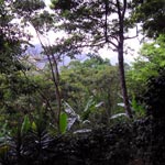
The mountain community of Rio Negro where the original Velasquez Family Farm is located is working hard to develop its tourism potential.
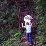
The community is beginning to develop a capacity to host visitors. Room and board can be arranged in several community member's homes and some, including Guillermo's brother Abilio, have built "eco-casitas" (small cabins) that can be rented out. Let us know if you are interested in visiting the farm and we can give you more information.
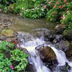
Rio Negro features an entry way to the beautiful cloud forest of the protected National Park of Comayagua which includes several hiking trails and gorgeous waterfalls. A Honduran travel guide book has this to say about the park:
"Only seven kilometers from Comayagua is the edge of Parque Nacional Montaña de Comayagua, covering 30,094 hectares, of which 6,600 hectares form the core zone. The highest point in the park is El Portillo, 2,407 meters. The forest is not one of the country's finest, certainly nothing compared to Celaque or Sierra de Agalta, but sizable patches of cloud forest remain, populated by quetzals, toucans, eagles, deer, monkeys and a few pumas."
"You can hike into the park from the villages of Rio Blanco and Rio Negro, both reached via dirt road from San JerĂłnimo, 12 kilometers from Comayagua by dirt road. Near Rio Negro is a lovely waterfall hidden amidst the dense forest, about a three hour hike roundtrip from Rio Negro. Several other hikes nearby are also possible, with guides (easily found in Rio Negro). Reputedly, two trucks leave Comayagua daily to Rio Negro, one shortly before and one shortly after midday - ask around near the market for more information. It's also possible to get out on the road early in the day and look for a jalĂłn. The drive to Rio Negro takes two bumpy hours."
—Excerpted from Honduras, by Chris Humphrey, Moon Handbooks, Third Edition, October 2003, page 443
Gabe Sidman, Peace Corp volunteer in Rio Negro 2008-2010 put together the following map of the area (click on the graphic below for better resolution). A pdf map with directions to the farm from Comayagua can be found here. Thanks to Gabe's work, Rio Negro is now on Google maps too.
